 |
|
Topics
|
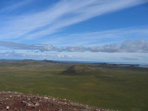
Island Natural Resources Basaltic lavas extruding onto a northwest trending structure on the southern Bering Sea Shelf (the Pribilof Ridge) formed the Pribilof Islands (Marlow et al. 1976; Marlow et al. 1994; Winer 2001, 4–7). Though the Bering Sea separates St. George and St. Paul Islands by only forty miles, the geology of the islands is quite different. Volcanic eruptions began on St. George about 2.2 million years ago (Ma), continuing intermittently until about 1.6 Ma (Cox et al. 1966). Following a hiatus of more than 1 million years, eruptions began building St. Paul Island, and possibly volcanism on the island has not yet ended (Cox et al. 1966). Thirteen thousand radiocarbon years before present, the Pribilof Islands were uplands on a large island lying among dozens of small islands (Guthrie 2004). Over the next several thousands of years, Bering Sea inundation claimed land, gradually decreasing the size of the Pribilof Islands. St. Paul Island reached its present size some time after 5,000 years before present. St. Paul Island is the youngest eruptive center in the Bering Sea basalt province, the last eruption occurring approximately 3,200 years ago at Fox Hill (Winer 2001, 19). The island has never been glaciated (Hopkins and Einarsson 1966). Its surface consists of more than fifteen scoria and spatter cones ranging from thirty to one hundred meters above their bases, surrounded by small shields of coalescing low viscosity lava flows (Winer 2001, 20). Headlands, sandy beaches, and wave-eroded cliffs comprise St. Paul Island’s shoreline.
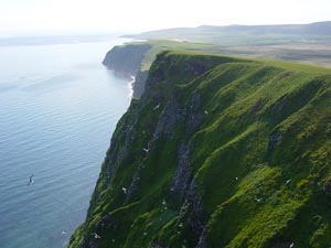
Cinder cones are absent on St. George Island. The island is an undulating highland with evidence of glacial erosion and deposition (Hopkins and Einarsson 1966). High Bluffs, the culmination of a narrow ridge extending along the western part of St. George Island’s north coast, is perhaps the most prominent topographic feature on the island. St. George Island has a few perennial streams (Hopkins and Einarsson 1966), in contrast to St. Paul Island which has no surface streams. The volcanic rocks of the Pribilof Islands are highly permeable; thus, most precipitation infiltrates and little runs off (Hopkins and Einarsson 1966).
|
 |
NOAA created this product in partial fulfillment
of a memorandum of agreement between it and the Alaska State Historic
Preservation Officer. |