 |
|
Topics
|
Island Setting
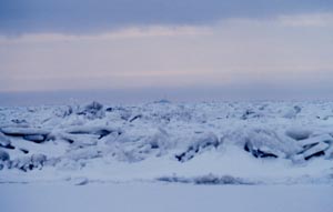
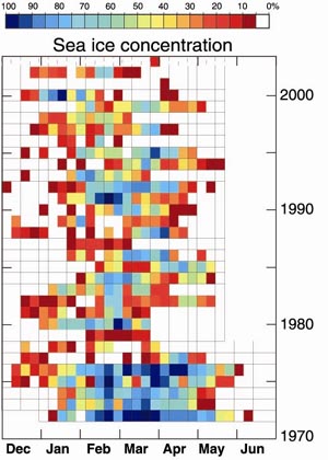
Prevailing winds advect sea ice southward in the Bering Sea (Stabeno and Overland 2001). The presence of sea ice influences water properties and the vertical structure of the water column (Stabeno et al. 1999b). The amount of seasonal sea ice is a defining characteristic of winter on the eastern continental shelf, and the degree of sea ice cover is an indicator of environmental conditions that will persist from winter through summer (Wyllie-Echeverria and Ohtani 1999). The residence time index (RTI) and the seasonal sea ice index (SSII) are two methods of indexing seasonal sea ice cover in the Bering Sea . RTI reflects the duration of ice each year in a gridded area. SSII is the southernmost position of sea ice along longitude 169° west. Both models show inter-annual and multi-annual variability between heavy and light ice cover, including a shift from heavy ice cover pre-1977 to lighter ice cover (Wyllie-Echeverria and Ohtani 1999). In 1989, the Arctic Oscillation (a phenomenon associated with the polar vortex) changed, and ice coverage slightly increased though it did not return to the cold years of the early 1970s (Stabeno and Overland 2001). Beginning in 2000, a marked decrease in ice cover occurred, with a near absence of sea ice over the southeastern Bering Sea ( Overland and Stabeno 2004). During 2005, 2006, 2007, and 2008 sea ice surrounded St. Paul Island. During 2007 and 2008 it reached St. George Island .
Humans and Bering Sea Resources
|
 |
NOAA created this product in partial fulfillment
of a memorandum of agreement between it and the Alaska State Historic
Preservation Officer. |